
Make a donation
Gear up for your next adventure:
As an Amazon Associate, this site earns from qualifying purchases at no extra cost to you.
Gudensberg topographic map
Click on the map to display elevation.
Make a donation
Gear up for your next adventure:
As an Amazon Associate, this site earns from qualifying purchases at no extra cost to you.
Gudensberg
The town's municipal area borders to the north and northeast on Edermünde, to the east on constituent communities of Felsberg which lie along the lower reaches of the river Eder. South and southeast of the river Ems lie further parts of Felsberg. To the south, southwest, and west are constituent communities of Fritzlar. To the northwest, Gudensberg's community of Gleichen abuts Niedenstein; in this direction, behind the Odenberg (elevation = 381 m (1,250 ft)), rise the Langenberge, (a low mountain range), that belong to the Habichtswald Nature Park.
Make a donation
Gear up for your next adventure:
As an Amazon Associate, this site earns from qualifying purchases at no extra cost to you.
About this map
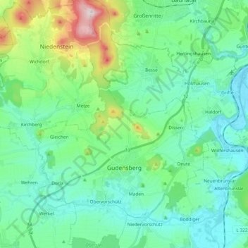
Name: Gudensberg topographic map, elevation, terrain.
Location: Gudensberg, Schwalm-Eder-Kreis, Hesse, 34281, Germany (51.13851 9.30249 51.25494 9.43050)
Average elevation: 234 m
Minimum elevation: 143 m
Maximum elevation: 559 m
Make a donation
Gear up for your next adventure:
As an Amazon Associate, this site earns from qualifying purchases at no extra cost to you.