Geolocate

Shortland topographic map

Click on the map to display elevation.

About this map
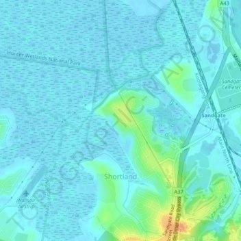
Name: Shortland topographic map, elevation, terrain.

Location: Shortland, Newcastle, Newcastle-Maitland, New South Wales, 2307, Australia (-32.89077 151.67388 -32.85695 151.70719)

Average elevation: 6 m

Minimum elevation: -2 m

Maximum elevation: 39 m

New South Wales trails, hiking, mountain biking, running and outdoor activities

Other topographic maps

Click on a map to view its topography, its elevation and its terrain.
Jesmond Park

Australia > New South Wales > Newcastle

Average elevation: 35 m

Redhead Bluff

Australia > New South Wales > Newcastle

Average elevation: 13 m

Cameron Park

Australia > New South Wales > Newcastle

Average elevation: 23 m

Glenrock Lagoon

Australia > New South Wales > Newcastle

Average elevation: 39 m

Nobbys Beach

Australia > New South Wales > Newcastle

Average elevation: 3 m

Dixon Park

Australia > New South Wales > Newcastle

Average elevation: 12 m

Gear up for your next adventure:

🔦LED Torches - LED torches for outdoor use
🧺Waterproof Dry Sacks - Organize your pack and keep electronics safe from rain and river crossings
🆘Personal Locator Beacons (PLB) - Satellite emergency beacons for life-saving help in areas with no mobile coverage
🎒Tactical Waist Packs - Quick access to your compass, phone, and snacks while walking
🥤Hydration Packs - Hydration systems for hiking

As an Amazon Associate, this site earns from qualifying purchases at no extra cost to you.