Geolocate

Addiewell topographic map

Interactive map

Click on the map to display elevation.

About this map

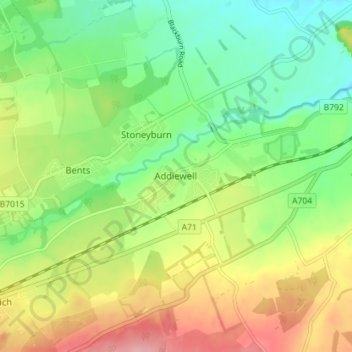
Name: Addiewell topographic map, elevation, terrain.

Location: Addiewell, West Lothian, Scotland, EH55 8HN, United Kingdom (55.82346 -3.64110 55.86346 -3.60110)

Average elevation: 196 m

Minimum elevation: 144 m

Maximum elevation: 271 m

Other topographic maps

Click on a map to view its topography, its elevation and its terrain.

Armadale

United Kingdom > Scotland > West Lothian

Armadale, West Lothian, Scotland, EH48 3QB, United Kingdom

Average elevation: 166 m

Pumpherston

United Kingdom > Scotland > West Lothian

Pumpherston, West Lothian, Scotland, EH53 0PQ, United Kingdom

Average elevation: 119 m