
Cherkasy topographic map
Interactive map
Click on the map to display elevation.
About this map
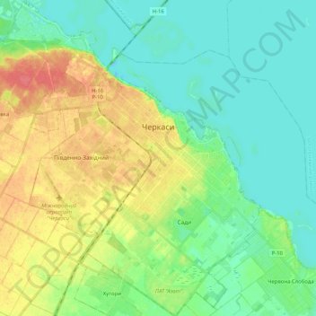
Name: Cherkasy topographic map, elevation, terrain.
Average elevation: 93 m
Minimum elevation: 74 m
Maximum elevation: 128 m
Other topographic maps
Click on a map to view its topography, its elevation and its terrain.
П’ятихатки
Ukraine > Cherkasy Oblast > Cherkasy
П’ятихатки, Kryvalivskyi microdistrict, Prydniprovskyi district, Cherkasy, Черкаська міська громада, Cherkasy Raion, Cherkasy Oblast, 18016, Ukraine
Average elevation: 96 m