Geolocate

Evergreen topographic map

Click on the map to display elevation.

Evergreen

Evergreen sits at an elevation of 7,220 feet (2,200 m) in the Rocky Mountains, 19 miles west of Denver, Colorado.

Wikipedia (CC-BY-SA 3.0)

About this map

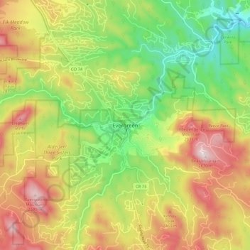
Name: Evergreen topographic map, elevation, terrain.

Location: Evergreen, Jefferson County, Colorado, 80457, United States (39.59285 -105.36330 39.67285 -105.28330)

Average elevation: 2,301 m

Minimum elevation: 2,027 m

Maximum elevation: 2,621 m

Other topographic maps

Click on a map to view its topography, its elevation and its terrain.

Arvada

United States > Colorado > Jefferson County

Average elevation: 1,665 m

Lakewood

United States > Colorado > Jefferson County > Lakewood

Lakewood is located at 39°42′17″N 105°04′53″W / 39.70472°N 105.08139°W / 39.70472; -105.08139 at an elevation of 5,518 feet (1,682 m). Located at the junction of U.S. Route 6 and Colorado State Highway 121 in central Colorado, the city lies immediately west of Denver and 62 miles (100 km)…

Average elevation: 1,717 m

Applewood

United States > Colorado > Jefferson County > Applewood

Average elevation: 1,738 m

Gear up for your next adventure:

🔭Compact Hiking Binoculars - Lightweight optics for scouting routes or birdwatching
🧰Survival Kits - Essential survival gear
Altimeter Barometer Watches - Outdoor watches with built-in sensors to track altitude changes and weather shifts
👕UPF 50+ Sun Shirts - Essential protection against the harsh Australian sun during field work
📕Australia Maps - Maps covering Australian regions

As an Amazon Associate, this site earns from qualifying purchases at no extra cost to you.