Geolocate

Dunedin topographic map

Click on the map to display elevation.

About this map

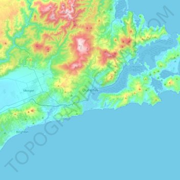
Name: Dunedin topographic map, elevation, terrain.

Location: Dunedin, Dunedin City, Otago, 9054, New Zealand (-46.03410 170.34358 -45.71410 170.66358)

Average elevation: 110 m

Minimum elevation: -1 m

Maximum elevation: 754 m

Other topographic maps

Click on a map to view its topography, its elevation and its terrain.

Logan Park

New Zealand > Otago > Dunedin City > Dunedin

Average elevation: 44 m

Waitati River

New Zealand > Otago > Dunedin City > Waitati

Average elevation: 259 m

Dunedin

New Zealand > Otago > Dunedin City

Average elevation: 143 m

Cragieburn

New Zealand > Otago > Dunedin City

Average elevation: 203 m

Otago Harbour

New Zealand > Otago > Dunedin City > Dunedin

Average elevation: 113 m

Gear up for your next adventure:

Lightweight Tents - Compact tents for backpacking
👖Convertible Hiking Trousers - Zip-off legs to adapt to changing temperatures throughout the day
🩹First Aid Kits - Emergency kits for hiking
🧊Insulated Stainless Steel Flasks - Keep water cold for 24 hours in the heat or coffee hot in the cold
Ultralight Solo Tents - Compact shelters for multi-day topographic surveying expeditions

As an Amazon Associate, this site earns from qualifying purchases at no extra cost to you.