
Kiruna kommun topographic map
Interactive map
Click on the map to display elevation.
About this map
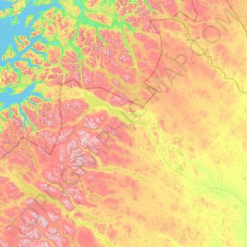
Name: Kiruna kommun topographic map, elevation, terrain.
Location: Kiruna kommun, Norrbotten County, Sweden (67.35628 17.89980 69.05997 23.28677)
Average elevation: 618 m
Minimum elevation: 0 m
Maximum elevation: 2,015 m
Other topographic maps
Click on a map to view its topography, its elevation and its terrain.
Muodoslompolo
Muodoslompolo, Pajala kommun, Norrbotten County, 984 85, Sweden
Average elevation: 238 m
Kalix kommun
Kalix kommun, Norrbotten County, Sweden
Average elevation: 33 m
Luleå kommun
Luleå kommun, Norrbotten County, Sweden
Average elevation: 64 m