
Make a donation
Gear up for your next adventure:
As an Amazon Associate, this site earns from qualifying purchases at no extra cost to you.
Maghreb topographic map
Click on the map to display elevation.
Make a donation
Gear up for your next adventure:
As an Amazon Associate, this site earns from qualifying purchases at no extra cost to you.
About this map
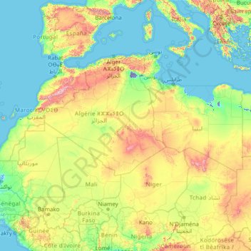
Name: Maghreb topographic map, elevation, terrain.
Location: Maghreb, Algeria (14.72099 -17.31902 37.76121 25.37706)
Average elevation: 352 m
Minimum elevation: -28 m
Maximum elevation: 3,557 m
Make a donation
Gear up for your next adventure:
As an Amazon Associate, this site earns from qualifying purchases at no extra cost to you.
Other topographic maps
Click on a map to view its topography, its elevation and its terrain.
Bordj el Bahri Faizi
Algeria > Algiers > Dar El Beida District > Bordj El Bahri > Bordj el Bahri Faizi
Average elevation: 19 m
Make a donation
Gear up for your next adventure:
As an Amazon Associate, this site earns from qualifying purchases at no extra cost to you.