
Thank you for supporting this site ❤️
Make a donation
Make a donation
Gear up for your next adventure:
As an Amazon Associate, this site earns from qualifying purchases at no extra cost to you.
Lembang topographic map
Click on the map to display elevation.
Thank you for supporting this site ❤️
Make a donation
Make a donation
Gear up for your next adventure:
As an Amazon Associate, this site earns from qualifying purchases at no extra cost to you.
About this map
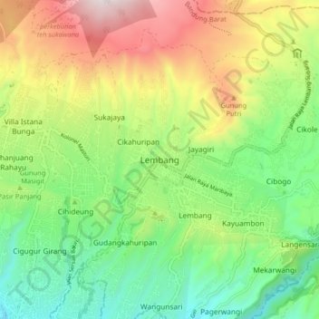
Name: Lembang topographic map, elevation, terrain.
Location: Lembang, West Bandung, West Java, Java, 40391, Indonesia (-6.85110 107.57712 -6.77110 107.65712)
Average elevation: 1,278 m
Minimum elevation: 902 m
Maximum elevation: 1,872 m
Thank you for supporting this site ❤️
Make a donation
Make a donation
Gear up for your next adventure:
As an Amazon Associate, this site earns from qualifying purchases at no extra cost to you.