Geolocate

Yokuts Valley topographic map

Click on the map to display elevation.

👉 Easily get elevation data in JSON, GeoTIFF and KML formats using Elevation API
Thank you for supporting this site ❤️
Make a donation

Gear up for your next adventure:

As an Amazon Associate, this site earns from qualifying purchases at no extra cost to you.

Yokuts Valley

As of the 2010 census, the CDP had a total population of 3,162, up from 2,691 at the 2000 census. Yokuts Valley is located 9 miles (14 km) north-northeast of Orange Cove and 30 miles (48 km) east of Fresno, at an elevation of 1,631 ft (497 m).

Wikipedia (CC-BY-SA 3.0)

About this map

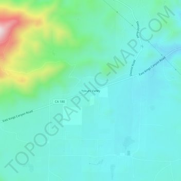
Name: Yokuts Valley topographic map, elevation, terrain.

Location: Yokuts Valley, Fresno County, California, 93675, United States (36.72023 -119.26679 36.76023 -119.22679)

Average elevation: 550 m

Minimum elevation: 445 m

Maximum elevation: 986 m

Gear up for your next adventure:

🧊Insulated Cooler Bags - Keep food fresh for day trips to remote geographic sites
📟Satellite Messengers - Two-way satellite communication to stay in touch beyond the cellular grid
Ultralight Solo Tents - Compact shelters for multi-day topographic surveying expeditions
🧼Biodegradable Soap - Eco-friendly outdoor soap
🧥Softshell Jackets - Flexible outdoor jackets

As an Amazon Associate, this site earns from qualifying purchases at no extra cost to you.