Geolocate

Dunfermline topographic map

Click on the map to display elevation.

About this map

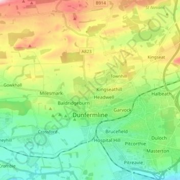
Name: Dunfermline topographic map, elevation, terrain.

Location: Dunfermline, Fife, Scotland, United Kingdom (56.04214 -3.51668 56.12292 -3.38718)

Average elevation: 114 m

Minimum elevation: 10 m

Maximum elevation: 309 m

Other topographic maps

Click on a map to view its topography, its elevation and its terrain.

Ladybank

United Kingdom > Scotland > Fife

Average elevation: 44 m

Lochore

United Kingdom > Scotland > Fife

Average elevation: 124 m

Kirkcaldy

United Kingdom > Scotland > Fife

Towards the end of the 16th century, a detailed assessment on the size of the townscape was carried out. The first estimate of the parish population in 1639 was between 3,000 and 3,200 and around 3,400 by 1691. At the beginning of the 18th century, the population declined. A census by Webster's Topographical…

Average elevation: 50 m

Gear up for your next adventure:

☀️Portable Solar Chargers - High-efficiency panels to hang on your backpack while walking
🔌Fast Charging Adapters - Quickly top up all your gear before heading back into the field
🔪Camping Knives - Multi-purpose outdoor knives
🖼️Scratch-off Australia Map - Track the regions and peaks you have explored geographically
🧥Insulated Down Jackets - High warmth-to-weight ratio for cold nights in the high country

As an Amazon Associate, this site earns from qualifying purchases at no extra cost to you.