
Make a donation
Gear up for your next adventure:
As an Amazon Associate, this site earns from qualifying purchases at no extra cost to you.
Dothan topographic map
Click on the map to display elevation.
Make a donation
Gear up for your next adventure:
As an Amazon Associate, this site earns from qualifying purchases at no extra cost to you.
Dothan
It is located in the Wiregrass region of southeastern Alabama, near both the Florida and Georgia state lines. The topography is generally flat and forested, with few small hills that gradually slope downward towards the Chattahoochee River to the east and the gulf coastal plain to the south.
Make a donation
Gear up for your next adventure:
As an Amazon Associate, this site earns from qualifying purchases at no extra cost to you.
About this map
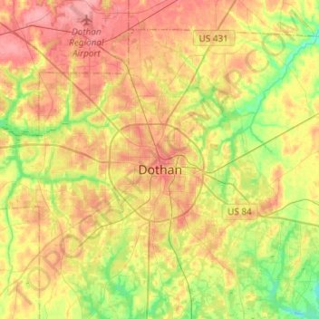
Name: Dothan topographic map, elevation, terrain.
Location: Dothan, Houston County, Alabama, United States (31.12622 -85.51967 31.33397 -85.29409)
Average elevation: 88 m
Minimum elevation: 48 m
Maximum elevation: 124 m
Make a donation
Gear up for your next adventure:
As an Amazon Associate, this site earns from qualifying purchases at no extra cost to you.
Other topographic maps
Click on a map to view its topography, its elevation and its terrain.
Make a donation
Gear up for your next adventure:
As an Amazon Associate, this site earns from qualifying purchases at no extra cost to you.