Geolocate

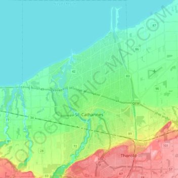
St. Catharines topographic map

Click on the map to display elevation.

St. Catharines

The most defining transportation icon of St. Catharines is the Welland Canal, a ship canal that runs 43.4 kilometres (27.0 mi), passing through the city. Four of its locks are within city boundaries. The canal allows shipping vessels to traverse the 99.5-metre (326.5 ft) drop in altitude from Lake Erie to Lake Ontario. The Garden City Skyway is a nearby bridge that facilitates vehicle traffic into the city.

Wikipedia (CC-BY-SA 3.0)

About this map

Name: St. Catharines topographic map, elevation, terrain.

Location: St. Catharines, Niagara Region, Golden Horseshoe, Ontario, Canada (43.10666 -79.32092 43.25001 -79.17783)

Average elevation: 103 m

Minimum elevation: 70 m

Maximum elevation: 195 m

Gear up for your next adventure:

📣High-Decibel Survival Whistles - Signaling tool for rescue that carries much further than a human voice
📡Satellite Messengers - Emergency communication devices
🍶Collapsible Water Bottles - Save space in your pack as you consume your water supply
🧤Thermal Hiking Gloves - Keep your hands warm and functional during high-altitude winter treks
🩹Blister Prevention Tape - Apply to friction points before they become painful sores

As an Amazon Associate, this site earns from qualifying purchases at no extra cost to you.