

Make a donation
Gear up for your next adventure:
As an Amazon Associate, this site earns from qualifying purchases at no extra cost to you.
Newbury topographic map
Click on the map to display elevation.
Make a donation
Gear up for your next adventure:
As an Amazon Associate, this site earns from qualifying purchases at no extra cost to you.
Newbury
Elevations vary from a minimum of 72 m above mean sea level to 122 m at Wash Common. Elevations reach 150–200 m in the directly adjoining hills. The River Kennet and the Kennet and Avon Canal flow east through the centre of the town to reach the Thames at Reading, while the River Lambourn (beside which is the country's largest horse-training paddocks in the Valley of the Lambourn Downs) partly forms its northern boundary, ending in the town. A tributary that is smaller still, the River Enborne, forms the southern boundary (and also the county boundary with Hampshire).
Make a donation
Gear up for your next adventure:
As an Amazon Associate, this site earns from qualifying purchases at no extra cost to you.
About this map
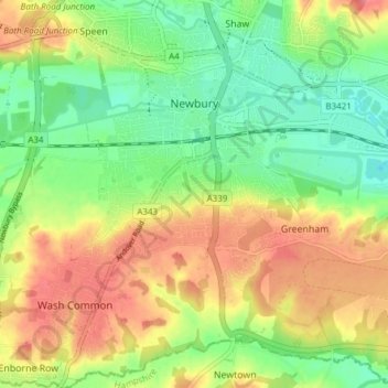
Name: Newbury topographic map, elevation, terrain.
Location: Newbury, West Berkshire, England, United Kingdom (51.36711 -1.35315 51.41456 -1.28819)
Average elevation: 97 m
Minimum elevation: 64 m
Maximum elevation: 135 m
Make a donation
Gear up for your next adventure:
As an Amazon Associate, this site earns from qualifying purchases at no extra cost to you.