
Thank you for supporting this site ❤️
Make a donation
Make a donation
Gear up for your next adventure:
As an Amazon Associate, this site earns from qualifying purchases at no extra cost to you.
Petal topographic map
Click on the map to display elevation.
Thank you for supporting this site ❤️
Make a donation
Make a donation
Gear up for your next adventure:
As an Amazon Associate, this site earns from qualifying purchases at no extra cost to you.
About this map
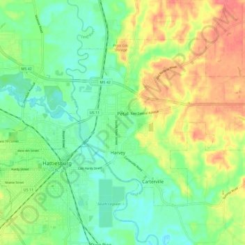
Name: Petal topographic map, elevation, terrain.
Location: Petal, Forrest County, Mississippi, 39465, United States (31.31030 -89.28618 31.37589 -89.17334)
Average elevation: 57 m
Minimum elevation: 32 m
Maximum elevation: 93 m
Thank you for supporting this site ❤️
Make a donation
Make a donation
Gear up for your next adventure:
As an Amazon Associate, this site earns from qualifying purchases at no extra cost to you.
Other topographic maps
Click on a map to view its topography, its elevation and its terrain.
Oseola McCarty Park
United States > Mississippi > Forrest County > Hattiesburg
Average elevation: 53 m