Geolocate
👉 Easily get elevation data in JSON, GeoTIFF and KML formats using Elevation API
Thank you for supporting this site ❤️
Make a donation

Rauma topographic map

Click on the map to display elevation.

About this map

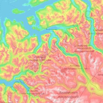
Name: Rauma topographic map, elevation, terrain.

Location: Rauma, Møre og Romsdal, Norway (62.17078 7.22546 62.72298 8.20585)

Average elevation: 769 m

Minimum elevation: -5 m

Maximum elevation: 1,959 m

Other topographic maps

Click on a map to view its topography, its elevation and its terrain.

Åndalsnes

Norway > Møre og Romsdal

Average elevation: 328 m

Trollveggen

Norway > Møre og Romsdal

Average elevation: 1,004 m

Skodje

Norway > Møre og Romsdal > Skodje

Average elevation: 78 m

Bolga

Norway > Møre og Romsdal

Average elevation: 109 m

Valle

Norway > Møre og Romsdal > Valle

Average elevation: 27 m

Ulsteinvik

Norway > Møre og Romsdal > Ulsteinvik

Average elevation: 150 m

Ålesund

Norway > Møre og Romsdal

Average elevation: 100 m

Gear up for your next adventure:

🪫Rechargeable Headlamps - USB rechargeable headlamps
🛌Sleeping Bags - Sleeping bags for outdoor camping
🧥Down Jackets - Insulated jackets for cold weather
🧢Outdoor Sun Hats - Sun protection hats for hiking
🚗Car Camping Gear - Equipment for vehicle camping

As an Amazon Associate, this site earns from qualifying purchases at no extra cost to you.