
Çorum topographic map
Interactive map
Click on the map to display elevation.
About this map
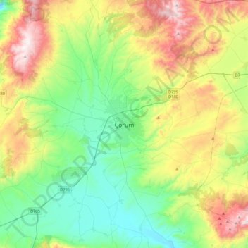
Name: Çorum topographic map, elevation, terrain.
Location: Çorum, Çorum merkez, Çorum, Black Sea Region, 19100, Turkey (40.38915 34.80025 40.70915 35.12025)
Average elevation: 1,044 m
Minimum elevation: 674 m
Maximum elevation: 1,783 m
Çorum (Turkish pronunciation: ; Medieval Greek: Ευχάνεια, romanized: Euchaneia) is a northern Anatolian city that is the capital of the Çorum Province of Turkey. Çorum is located inland in the central Black Sea Region of Turkey, and is approximately 244 km (152 mi) from Ankara and 608 km (378 mi) from Istanbul. The city has an elevation of 801 m (2,628 ft) above sea level, a surface area of 12,820 km2 (4,950 sq mi), and as of the 2016 census, a population of 237,000.