
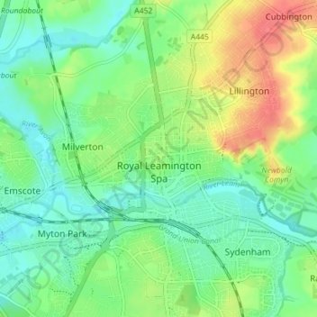
Royal Leamington Spa topographic map
Interactive map
Click on the map to display elevation.
About this map
Name: Royal Leamington Spa topographic map, elevation, terrain.
Average elevation: 66 m
Minimum elevation: 46 m
Maximum elevation: 100 m
Other topographic maps
Click on a map to view its topography, its elevation and its terrain.
Stratford-upon-Avon
United Kingdom > England > Warwickshire > Stratford-on-Avon
Stratford-upon-Avon, Stratford-on-Avon, Warwickshire, England, United Kingdom
Average elevation: 61 m
Newbold on Avon
United Kingdom > England > Warwickshire > Rugby
Newbold on Avon, Rugby, Warwickshire, England, CV21 1HQ, United Kingdom
Average elevation: 98 m
Bilton
United Kingdom > England > Warwickshire > Rugby
Bilton, Rugby, Warwickshire, England, CV22 7NL, United Kingdom
Average elevation: 111 m
Ilmington CP
United Kingdom > England > Warwickshire > Stratford-on-Avon
Ilmington CP, Stratford-on-Avon, Warwickshire, England, United Kingdom
Average elevation: 123 m
Great Alne
United Kingdom > England > Warwickshire > Stratford-on-Avon
Great Alne, Stratford-on-Avon, Warwickshire, England, B49 6HJ, United Kingdom
Average elevation: 64 m
Warwick
United Kingdom > England > Warwickshire
Warwick, Warwickshire, England, United Kingdom
Average elevation: 87 m
Nuneaton
United Kingdom > England > Warwickshire > Nuneaton and Bedworth > Nuneaton
Nuneaton, Nuneaton and Bedworth, Warwickshire, West Midlands, England, CV11 5AB, United Kingdom
Average elevation: 101 m
Bedworth
United Kingdom > England > Warwickshire > Nuneaton and Bedworth > Bedworth
Bedworth, Nuneaton and Bedworth, Warwickshire, West Midlands, England, CV12 9DQ, United Kingdom
Average elevation: 105 m
West Midlands
United Kingdom > England > Warwickshire
West Midlands, Warwickshire, West Midlands Combined Authority, England, United Kingdom
Average elevation: 113 m
Rugby
United Kingdom > England > Warwickshire
Rugby, Warwickshire, England, United Kingdom
Average elevation: 112 m
Stratford-upon-Avon
United Kingdom > England > Warwickshire > Stratford-on-Avon > Stratford-upon-Avon
Stratford-upon-Avon, Stratford-on-Avon, Warwickshire, West Midlands, England, CV37 6AH, United Kingdom
Average elevation: 58 m