Geolocate
👉 Easily get elevation data in JSON, GeoTIFF and KML formats using Elevation API
Thank you for supporting this site ❤️
Make a donation

Gear up for your next adventure:

As an Amazon Associate, this site earns from qualifying purchases at no extra cost to you.

Tuburan topographic map

Click on the map to display elevation.

About this map

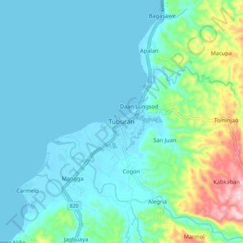
Name: Tuburan topographic map, elevation, terrain.

Location: Tuburan, Cebu, Central Visayas, 6043, Philippines (10.68854 123.78542 10.76854 123.86542)

Average elevation: 48 m

Minimum elevation: -1 m

Maximum elevation: 269 m

Gear up for your next adventure:

🍶Collapsible Water Bottles - Save space in your pack as you consume your water supply
🧊Insulated Stainless Steel Flasks - Keep water cold for 24 hours in the heat or coffee hot in the cold
🚴Cycling Backpacks - Backpacks for cyclists
📷Backpack Camera Clips - Quick access to your camera while keeping your hands free for climbing
🧢Outdoor Sun Hats - Sun protection hats for hiking

As an Amazon Associate, this site earns from qualifying purchases at no extra cost to you.