
Make a donation
Gear up for your next adventure:
As an Amazon Associate, this site earns from qualifying purchases at no extra cost to you.
Town of Pound Ridge topographic map
Click on the map to display elevation.
Make a donation
Gear up for your next adventure:
As an Amazon Associate, this site earns from qualifying purchases at no extra cost to you.
About this map
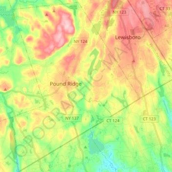
Name: Town of Pound Ridge topographic map, elevation, terrain.
Average elevation: 156 m
Minimum elevation: 67 m
Maximum elevation: 262 m
Make a donation
Gear up for your next adventure:
As an Amazon Associate, this site earns from qualifying purchases at no extra cost to you.
Other topographic maps
Click on a map to view its topography, its elevation and its terrain.
Pleasantside
United States > New York > Westchester County > Town of Cortlandt
Average elevation: 108 m
Make a donation
Gear up for your next adventure:
As an Amazon Associate, this site earns from qualifying purchases at no extra cost to you.
Mariandale
United States > New York > Westchester County > Village of Ossining
Average elevation: 53 m
Sunset Ridge
United States > New York > Westchester County > Town/Village of Harrison
Average elevation: 27 m
Make a donation
Gear up for your next adventure:
As an Amazon Associate, this site earns from qualifying purchases at no extra cost to you.
Mount Hope
United States > New York > Westchester County > Village of Hastings-on-Hudson
Average elevation: 60 m
South Salem
United States > New York > Westchester County > Town of Lewisboro
Average elevation: 174 m
Colonial Heights
United States > New York > Westchester County > City of Yonkers
Average elevation: 60 m
Make a donation
Gear up for your next adventure:
As an Amazon Associate, this site earns from qualifying purchases at no extra cost to you.
Heath Ridge
United States > New York > Westchester County > Village of Scarsdale
Average elevation: 66 m
Make a donation
Gear up for your next adventure:
As an Amazon Associate, this site earns from qualifying purchases at no extra cost to you.
Whitehall Corners
United States > New York > Westchester County > Town of Somers
Average elevation: 97 m
Hawthorne
United States > New York > Westchester County > Town of Mount Pleasant
Average elevation: 119 m
West Harrison
United States > New York > Westchester County > Town/Village of Harrison
Average elevation: 81 m
Make a donation
Gear up for your next adventure:
As an Amazon Associate, this site earns from qualifying purchases at no extra cost to you.
Quarry Heights
United States > New York > Westchester County > Town/Village of Harrison
Average elevation: 112 m
Purdys Grove
United States > New York > Westchester County > Village of Port Chester
Average elevation: 14 m
Make a donation
Gear up for your next adventure:
As an Amazon Associate, this site earns from qualifying purchases at no extra cost to you.
Sleepy Hollow Manor
United States > New York > Westchester County > Village of Sleepy Hollow
Average elevation: 41 m
Beechmont
United States > New York > Westchester County > City of New Rochelle
Average elevation: 31 m
Make a donation
Gear up for your next adventure:
As an Amazon Associate, this site earns from qualifying purchases at no extra cost to you.
Whitehall Corners
United States > New York > Westchester County > Town of Somers
Average elevation: 97 m
South Ridge
United States > New York > Westchester County > Village of Rye Brook
Average elevation: 37 m
Whitehall Corners
United States > New York > Westchester County > Town of Somers
Average elevation: 97 m
Make a donation
Gear up for your next adventure:
As an Amazon Associate, this site earns from qualifying purchases at no extra cost to you.
Lake Lincolndale
United States > New York > Westchester County > Town of Somers > Shenorock
Average elevation: 162 m
Murdock Woods
United States > New York > Westchester County > Town of Mamaroneck
Average elevation: 46 m
Lake Katonah
United States > New York > Westchester County > Town of Lewisboro
Average elevation: 127 m
Sun Haven
United States > New York > Westchester County > City of New Rochelle
Average elevation: 20 m
Make a donation
Gear up for your next adventure:
As an Amazon Associate, this site earns from qualifying purchases at no extra cost to you.
Turkey Mountain
United States > New York > Westchester County > Town of Yorktown
Average elevation: 142 m
Mohegan Heights
United States > New York > Westchester County > City of Yonkers
Average elevation: 58 m
Buckhout Corners
United States > New York > Westchester County > Village of Briarcliff Manor
Average elevation: 112 m
Salem Center
United States > New York > Westchester County > Town of North Salem
Average elevation: 147 m
Make a donation
Gear up for your next adventure:
As an Amazon Associate, this site earns from qualifying purchases at no extra cost to you.
Furnace Woods
United States > New York > Westchester County > Town of Cortlandt
Average elevation: 116 m
Murray Hill
United States > New York > Westchester County > Village of Scarsdale
Average elevation: 79 m
Isle of San Souci
United States > New York > Westchester County > City of New Rochelle
Average elevation: 7 m
Wykagyl Park
United States > New York > Westchester County > City of New Rochelle
Average elevation: 41 m
Make a donation
Gear up for your next adventure:
As an Amazon Associate, this site earns from qualifying purchases at no extra cost to you.
Getty Square
United States > New York > Westchester County > City of Yonkers > Ludlow
Average elevation: 31 m
Van Cortlandtville
United States > New York > Westchester County > Town of Cortlandt
Average elevation: 80 m
Park Hill
United States > New York > Westchester County > City of Yonkers > Park Hill
Average elevation: 43 m
West Mount Vernon
United States > New York > Westchester County > City of Mount Vernon
Average elevation: 49 m
Make a donation
Gear up for your next adventure:
As an Amazon Associate, this site earns from qualifying purchases at no extra cost to you.
Vista
United States > New York > Westchester County > Town of Lewisboro > Vista
Average elevation: 154 m
Van Cortlandtville
United States > New York > Westchester County > Town of Cortlandt
Average elevation: 80 m
Bedford Hills
United States > New York > Westchester County > Town of Bedford > Bedford Hills
Average elevation: 114 m