
Garson topographic map
Interactive map
Click on the map to display elevation.
About this map
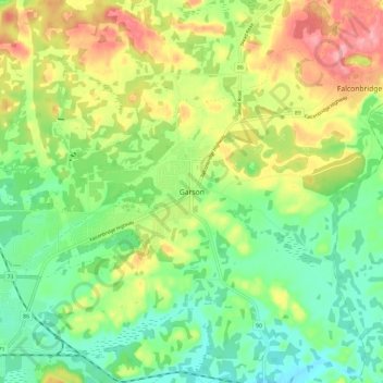
Name: Garson topographic map, elevation, terrain.
Average elevation: 292 m
Minimum elevation: 251 m
Maximum elevation: 352 m
Other topographic maps
Click on a map to view its topography, its elevation and its terrain.
Copper Cliff
Canada > Ontario > Sudbury District > Greater Sudbury
Copper Cliff, Greater Sudbury, Sudbury District, Northeastern Ontario, Ontario, P0M 1N0, Canada
Average elevation: 286 m
Massey Creek
Canada > Ontario > Sudbury District > Greater Sudbury
Massey Creek, Greater Sudbury, Sudbury District, Northeastern Ontario, Ontario, Canada
Average elevation: 318 m