
Make a donation
Gear up for your next adventure:
As an Amazon Associate, this site earns from qualifying purchases at no extra cost to you.
Carson City topographic map
Click on the map to display elevation.
Make a donation
Gear up for your next adventure:
As an Amazon Associate, this site earns from qualifying purchases at no extra cost to you.
Carson City
Most of the city proper resides in the Eagle Valley. The Carson River flows from Douglas County through the southwestern edge of both the valley and Carson City. Since the consolidation, the city limits today include several small populated areas outside of this valley. Today the city limits include several peaks in the Sierra Nevada, small portions of both the Virginia Range and the Pine Nut Mountains and portions of Marlette Lake and Lake Tahoe. The highest elevation in city limits is Snow Valley Peak at an elevation of 9,214 feet (2,808 m). Carson City is one of two state capitals that border another state, the other being Trenton, New Jersey.
Make a donation
Gear up for your next adventure:
As an Amazon Associate, this site earns from qualifying purchases at no extra cost to you.
About this map
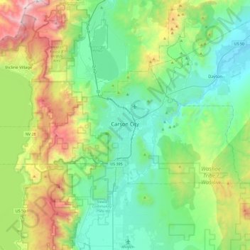
Name: Carson City topographic map, elevation, terrain.
Location: Carson City, Nevada, United States (39.08480 -120.00449 39.25087 -119.54831)
Average elevation: 1,825 m
Minimum elevation: 1,310 m
Maximum elevation: 3,269 m
Make a donation
Gear up for your next adventure:
As an Amazon Associate, this site earns from qualifying purchases at no extra cost to you.
Other topographic maps
Click on a map to view its topography, its elevation and its terrain.
Make a donation
Gear up for your next adventure:
As an Amazon Associate, this site earns from qualifying purchases at no extra cost to you.