Ruidoso topographic map
Click on the map to display elevation.
Ruidoso
Ruidoso is in southern Lincoln County, with elevations ranging from 6,400 feet (2,000 m) at the village's southeast corner in the valley of the Rio Ruidoso up to over 7,700 feet (2,300 m) at the village's northern end near Alto. Ruidoso's southern border and westernmost border follow the Otero County line. The village is bordered to the east by the city of Ruidoso Downs. U.S. Route 70 passes through the southeast part of the village, following the valley of Carrizo Creek upstream from the Rio Ruidoso. The highway leads east down the valley of the Rio Ruidoso and Rio Hondo 70 miles (110 km) to Roswell and southwest over Apache Summit 33 miles (53 km) to Tularosa. New Mexico State Road 48 passes through the center of Ruidoso on Sudderth Drive, the village's main street, and leads north 18 miles (29 km) to Capitan.
About this map
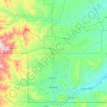
Name: Ruidoso topographic map, elevation, terrain.
Location: Ruidoso, Lincoln County, New Mexico, United States (33.30509 -105.72620 33.47534 -105.50369)
Average elevation: 2,287 m
Minimum elevation: 1,887 m
Maximum elevation: 3,285 m
Other topographic maps
Click on a map to view its topography, its elevation and its terrain.

Alto
United States > New Mexico > Lincoln County
Alto is located at an elevation of 7,550 feet (2,300 m) in the Lincoln National Forest, five miles (8.0 km) north of the village of Ruidoso. Alto received its name from the Spanish word "high" because of its elevation.
Average elevation: 2,285 m

Alto
United States > New Mexico > Lincoln County
Alto is located at an elevation of 7,550 feet (2,300 m) in the Lincoln National Forest, five miles (8.0 km) north of the village of Ruidoso. Alto received its name from the Spanish word "high" because of its elevation.
Average elevation: 2,285 m