
Cary topographic map
Click on the map to display elevation.
Cary
Cary is seated on the boundary between the Durham Basin with its softer sedimentary rocks and the piedmont with its harder metamorphic rocks; both geologic provinces have igneous rock intrusions. The landscape is typically gentle to moderate sloping hills separated by narrow V-shaped valleys, but there are areas with steeper slopes and broader, U-shaped valleys in western Cary, roughly along NC 55 near the Research Triangle Park and north of Green Hope School Road. Cary's average elevation is 495 ft (151 m).
About this map
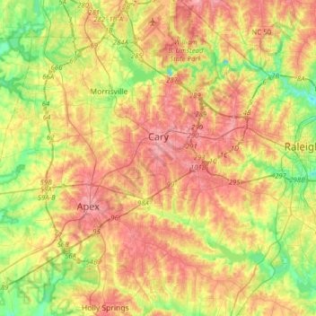
Name: Cary topographic map, elevation, terrain.
Location: Cary, Wake County, North Carolina, United States (35.64438 -78.95380 35.89688 -78.72946)
Average elevation: 111 m
Minimum elevation: 60 m
Maximum elevation: 160 m
Other topographic maps
Click on a map to view its topography, its elevation and its terrain.
Lake Johnson
United States > North Carolina > Wake County > Raleigh > Orchards
Average elevation: 121 m
Prestonwood Soccer Complex
United States > North Carolina > Wake County > Cary
Average elevation: 111 m
Lake Raleigh
United States > North Carolina > Wake County > Raleigh > Isle Forest
Average elevation: 104 m