
Arco topographic map
Click on the map to display elevation.
About this map
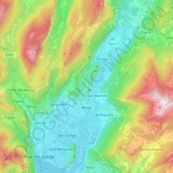
Name: Arco topographic map, elevation, terrain.
Average elevation: 699 m
Minimum elevation: 55 m
Maximum elevation: 2,035 m
Other topographic maps
Click on a map to view its topography, its elevation and its terrain.
Palette
Italy > Trentino-Alto Adige/Südtirol > Provincia di Trento > Spiazzo
Average elevation: 1,714 m
Baldal
Italy > Trentino-Alto Adige/Südtirol > Provincia di Trento > Palù del Fersina - Palai en Bersntol > Palai en Bersntol - Palù del Fersina
Average elevation: 1,758 m