
Salamanca topographic map
Interactive map
Click on the map to display elevation.
About this map
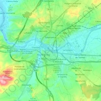
Name: Salamanca topographic map, elevation, terrain.
Location: Salamanca, Castile and León, Spain (40.91463 -5.73580 40.99319 -5.62262)
Average elevation: 812 m
Minimum elevation: 763 m
Maximum elevation: 935 m
With an altitude of over 800 meters, Salamanca has a warm-summer Mediterranean climate (Csb) according to the Köppen climate classification, with some cold semi-arid climate (BSk) climatic influences, resulting in large diurnal temperature variations, with hot summers and chilly winters, and nearly-semi-arid levels of precipitation. Salamanca does not have a real wet season. Most of the precipitation falls outside of the summer, with upticks at the end of the spring and during the winter; all winters have snow during few days per year, although heavy snowfalls are uncommon, but not unheard of. The city averages around 7 days of snowy days per year, morning frost during winters is very common, as on a normal year, Salamanca has on average 76 days with low temperatures below freezing.
Other topographic maps
Click on a map to view its topography, its elevation and its terrain.
Mijares
Mijares, Ávila, Castile and León, 05461, Spain
Average elevation: 932 m
Guimares
Spain > Castile and León > Gallegos del Río
Guimares, Domez de Alba, Gallegos del Río, Zamora, Castile and León, Spain
Average elevation: 744 m
Ponferrada
Spain > Castile and León > El Bierzo
Ponferrada, El Bierzo, León, Castile and León, Spain
Average elevation: 883 m
Espinosa de los Monteros
Spain > Castile and León > Espinosa de los Monteros
Espinosa de los Monteros, Burgos, Castile and León, Spain
Average elevation: 919 m
Los Santos
Spain > Castile and León > Los Santos
Los Santos, Salamanca, Castile and León, 37768, Spain
Average elevation: 936 m
El Yuste
Spain > Castile and León > El Hoyo de Pinares
El Yuste, El Hoyo de Pinares, Ávila, Castile and León, Spain
Average elevation: 959 m
Villares de la Reina
Spain > Castile and León > Villares de la Reina
Villares de la Reina, Salamanca, Castile and León, Spain
Average elevation: 820 m
Riaño
Spain > Castile and León > Riaño
Riaño, Castile and León, 24900, Spain
Average elevation: 1,140 m
La Tala
Spain > Castile and León > La Tala
La Tala, Guijuelo, Castile and León, Spain
Average elevation: 946 m
Arapiles
Arapiles, Salamanca, Castile and León, Spain
Average elevation: 842 m
San Justo
Spain > Castile and León > San Justo
San Justo, Galende, Castile and León, Spain
Average elevation: 1,332 m
Buenavista
Buenavista, Guijuelo, Castile and León, 37789, Spain
Average elevation: 936 m
La Maya
Spain > Castile and León > La Maya
La Maya, Tierra de Alba, Salamanca, Castile and León, Spain
Average elevation: 850 m
Roa
Spain > Castile and León > Roa
Roa, Ribera del Duero, Burgos, Castile and León, Spain
Average elevation: 835 m
Calatañazor
Spain > Castile and León > Calatañazor
Calatañazor, Comarca de Soria, Soria, Castile and León, 42193, Spain
Average elevation: 1,092 m
Palencia
Spain > Castile and León > Palencia
Palencia, Castile and León, Spain
Average elevation: 794 m
El Pipón
Spain > Castile and León > Almarza
El Pipón, Almarza, El Valle, Soria, Castile and León, 42164, Spain
Average elevation: 1,145 m
Atua
Spain > Castile and León > Condado de Treviño
Atua, Condado de Treviño, Miranda de Ebro, Castile and León, Spain
Average elevation: 629 m
Contreras
Spain > Castile and León > Contreras
Contreras, Sierra de la Demanda, Burgos, Castile and León, Spain
Average elevation: 1,089 m
Pico Almanzor
Spain > Castile and León > Candeleda
Pico Almanzor, Candeleda, Comarca de Arenas de San Pedro, Ávila, Castile and León, Spain
Average elevation: 2,159 m
Cantagallo
Spain > Castile and León > Cantagallo > Cantagallo
Cantagallo, Béjar, Castile and León, Spain
Average elevation: 996 m