
Shanghai topographic map
Click on the map to display elevation.
Shanghai
The golden age of Shanghai began with its elevation to municipality on 7 July 1927. This new Chinese municipality covered an area of 494.69 km2 (191.0 sq mi), including the modern-day districts of Baoshan, Yangpu, Zhabei, Nanshi, and Pudong, but excluded the foreign concessions territories. Headed by a Chinese mayor and municipal council, the new city government's first task—the Greater Shanghai Plan—was to create a new city center in Jiangwan town of Yangpu district, outside the boundaries of the foreign concessions. The plan included a public museum, library, sports stadium, and city hall, which were partially constructed before being interrupted by the Japanese invasion.
About this map
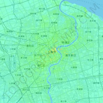
Name: Shanghai topographic map, elevation, terrain.
Location: Shanghai, Huangpu District, Shanghai, 200001, China (31.07234 121.30910 31.39234 121.62910)
Average elevation: 5 m
Minimum elevation: -6 m
Maximum elevation: 40 m
Other topographic maps
Click on a map to view its topography, its elevation and its terrain.