
Qinghai Lake topographic map
Interactive map
Click on the map to display elevation.
About this map
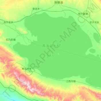
Name: Qinghai Lake topographic map, elevation, terrain.
Location: Qinghai Lake, Qinghai, China (36.54811 99.62069 37.23741 100.76020)
Average elevation: 3,332 m
Minimum elevation: 3,005 m
Maximum elevation: 4,636 m
Other topographic maps
Click on a map to view its topography, its elevation and its terrain.
Haixi Mongol and Tibetan Autonomous Prefecture
Haixi Mongol and Tibetan Autonomous Prefecture, Qinghai, China
Average elevation: 3,739 m
Ulan County
Ulan County, Haixi Mongol and Tibetan Autonomous Prefecture, Qinghai, 817100, China
Average elevation: 3,593 m
Yanshiping
China > Qinghai > Yanshiping
Yanshiping, Golmud City, Haixi Mongol and Tibetan Autonomous Prefecture, Qinghai, China
Average elevation: 4,958 m
Qumarlêb County
Qumarlêb County, Yushu Tibetan Autonomous Prefecture, Qinghai, China
Average elevation: 4,505 m