
Make a donation
Gear up for your next adventure:
As an Amazon Associate, this site earns from qualifying purchases at no extra cost to you.
Santa Fe topographic map
Click on the map to display elevation.
Make a donation
Gear up for your next adventure:
As an Amazon Associate, this site earns from qualifying purchases at no extra cost to you.
Santa Fe
With a population of 87,505 at the 2020 census, it is the fourth-largest city in New Mexico. It is also the county seat of Santa Fe County. Its metropolitan area is part of the Albuquerque–Santa Fe–Las Vegas combined statistical area, which had a population of 1,162,523 in 2020. Human settlement dates back thousands of years in the region, the placita was founded in 1610 as the capital of Nuevo México. It replaced the previous capital, San Juan de los Caballeros, near modern Española, at San Gabriel de Yungue-Ouinge, which makes it the oldest state capital in the United States. It is also at the highest altitude of any of the U.S. state capitals, with an elevation of 7,199 feet (2,194 m).
Make a donation
Gear up for your next adventure:
As an Amazon Associate, this site earns from qualifying purchases at no extra cost to you.
About this map
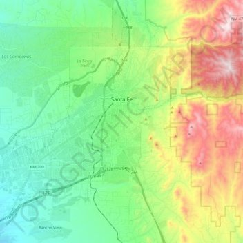
Name: Santa Fe topographic map, elevation, terrain.
Location: Santa Fe, Santa Fe County, New Mexico, United States (35.58804 -106.11216 35.75462 -105.89418)
Average elevation: 2,221 m
Minimum elevation: 1,915 m
Maximum elevation: 2,862 m
Make a donation
Gear up for your next adventure:
As an Amazon Associate, this site earns from qualifying purchases at no extra cost to you.