Geolocate

Kingsford topographic map

Click on the map to display elevation.

About this map

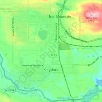
Name: Kingsford topographic map, elevation, terrain.

Location: Kingsford, Dickinson County, Michigan, 49802, United States (45.78470 -88.13621 45.82278 -88.06652)

Average elevation: 350 m

Minimum elevation: 286 m

Maximum elevation: 482 m

Other topographic maps

Click on a map to view its topography, its elevation and its terrain.

Felch

United States > Michigan > Dickinson County

Average elevation: 353 m

Metropolitan

United States > Michigan > Dickinson County

Average elevation: 371 m

Gear up for your next adventure:

🦟Insect Repellent - Protection against insects
🥤Outdoor Water Bottles - Reusable bottles for outdoor activities
Altimeter Barometer Watches - Outdoor watches with built-in sensors to track altitude changes and weather shifts
🔪Multitools - Compact tools for outdoor use
🧥Packable Rain Jackets - Breathable waterproof layers for unpredictable mountain weather

As an Amazon Associate, this site earns from qualifying purchases at no extra cost to you.