
Make a donation
Gear up for your next adventure:
As an Amazon Associate, this site earns from qualifying purchases at no extra cost to you.
Groesbeek topographic map
Click on the map to display elevation.
Make a donation
Gear up for your next adventure:
As an Amazon Associate, this site earns from qualifying purchases at no extra cost to you.
Groesbeek
Due to this, the topography is much more varied here than in other higher grounds with similar origins in the Netherlands. Finally, during the Younger Dryas stadial, large amounts of loess were deposited in the valley, making it extremely fertile, while the hills around it are composed to this day of sandy loam unsuitable for intensive agriculture, so that the area has been covered with thick forests to this day. This contributed to the isolation of the area, especially considering the extent of the forests in the Middle Ages was much larger than today. The isolation of the valley was only alleviated by the arrival of the railway in 1865 and finally lifted in the interbellum by the construction of a high capacity paved road to nearby Nijmegen.
Make a donation
Gear up for your next adventure:
As an Amazon Associate, this site earns from qualifying purchases at no extra cost to you.
About this map
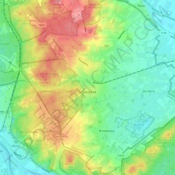
Name: Groesbeek topographic map, elevation, terrain.
Location: Groesbeek, Berg en Dal, Gelderland, Netherlands (51.74103 5.87940 51.81056 5.99207)
Average elevation: 41 m
Minimum elevation: 6 m
Maximum elevation: 93 m
Make a donation
Gear up for your next adventure:
As an Amazon Associate, this site earns from qualifying purchases at no extra cost to you.
Other topographic maps
Click on a map to view its topography, its elevation and its terrain.
Make a donation
Gear up for your next adventure:
As an Amazon Associate, this site earns from qualifying purchases at no extra cost to you.