
Make a donation
Gear up for your next adventure:
As an Amazon Associate, this site earns from qualifying purchases at no extra cost to you.
Emi Koussi topographic map
Click on the map to display elevation.
Make a donation
Gear up for your next adventure:
As an Amazon Associate, this site earns from qualifying purchases at no extra cost to you.
Emi Koussi
Emi Koussi (also known as Emi Koussou) is a high pyroclastic shield volcano that lies at the southeast end of the Tibesti Mountains in the central Sahara, in the northern Borkou Region of northern Chad. The highest mountain of the Sahara, the volcano is one of several in the Tibesti range, and reaches an elevation of 3,415 metres (11,204 ft), rising 3 km (1.9 mi) above the surrounding sandstone plains. The volcano is 60–70 kilometres (37–43 mi) wide and has a volume of 2,500 cubic kilometres (600 cu mi).
Make a donation
Gear up for your next adventure:
As an Amazon Associate, this site earns from qualifying purchases at no extra cost to you.
About this map
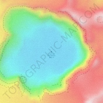
Name: Emi Koussi topographic map, elevation, terrain.
Location: Emi Koussi, Tibesti, Chad (19.83259 18.56085 19.83269 18.56095)
Average elevation: 2,904 m
Minimum elevation: 2,666 m
Maximum elevation: 3,203 m
Make a donation
Gear up for your next adventure:
As an Amazon Associate, this site earns from qualifying purchases at no extra cost to you.