Geolocate

Melbourne topographic map

Click on the map to display elevation.

About this map

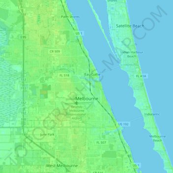
Name: Melbourne topographic map, elevation, terrain.

Location: Melbourne, Brevard County, Florida, United States (28.03501 -80.74826 28.20053 -80.57494)

Average elevation: 5 m

Minimum elevation: -2 m

Maximum elevation: 24 m

Other topographic maps

Click on a map to view its topography, its elevation and its terrain.

Melbourne

United States > Florida > Brevard County > Melbourne

Average elevation: 6 m

Micco

United States > Florida > Brevard County

Average elevation: 6 m

Melbourne

United States > Florida > Brevard County > Melbourne

Average elevation: 4 m

Cape Canaveral

United States > Florida > Brevard County

The hurricane of August 1885, pushed a "wall of water" over the barrier island (elevation, 3.1 m (10 ft)) devastating Cape Canaveral and adjacent areas. The ocean waves flooded the homesteaders and discouraged further settlement in the area. The beach near the lighthouse was severely eroded prompting its…

Average elevation: 1 m

Gear up for your next adventure:

🧣Merino Neck Gaiters - Versatile headwear for warmth, sun protection, or dust filtering
🗺️Topographic Maps - Detailed maps for hiking and navigation
🩹Blister Prevention Tape - Apply to friction points before they become painful sores
🌧️Rain Jackets - Waterproof jackets for hiking
📕Australia Maps - Maps covering Australian regions

As an Amazon Associate, this site earns from qualifying purchases at no extra cost to you.