Geolocate

Ellerslie topographic map

Click on the map to display elevation.

About this map

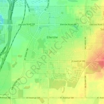
Name: Ellerslie topographic map, elevation, terrain.

Location: Ellerslie, Edmonton, Alberta, Canada (53.39560 -113.51177 53.43228 -113.44242)

Average elevation: 699 m

Minimum elevation: 675 m

Maximum elevation: 729 m

Other topographic maps

Click on a map to view its topography, its elevation and its terrain.

William Hawrelak Park

Canada > Alberta > Edmonton

Average elevation: 649 m

Ormsby Park

Canada > Alberta > Edmonton

Average elevation: 688 m

Horseshoe Lake

Canada > Alberta > Edmonton

Average elevation: 680 m

Gear up for your next adventure:

Survival Blankets - Emergency thermal blankets
👄SPF Lip Balm - Prevent sun and wind-burnt lips on mountain ridges
🧊Insulated Cooler Bags - Keep food fresh for day trips to remote geographic sites
🎒Tactical Waist Packs - Quick access to your compass, phone, and snacks while walking
🔦Powerful LED Headlamps - Hands-free lighting for night navigation and setting up camp after dark

As an Amazon Associate, this site earns from qualifying purchases at no extra cost to you.