Geolocate

Porac topographic map

Click on the map to display elevation.

About this map

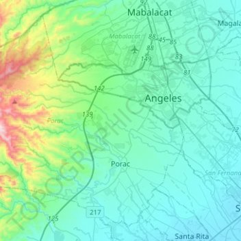
Name: Porac topographic map, elevation, terrain.

Location: Porac, Pampanga, Central Luzon, 2008, Philippines (15.00970 120.35851 15.22204 120.60911)

Average elevation: 170 m

Minimum elevation: 5 m

Maximum elevation: 1,030 m

Other topographic maps

Click on a map to view its topography, its elevation and its terrain.

Porac

Philippines > Pampanga > Porac

Average elevation: 91 m

Purok 1

Philippines > Pampanga > San Juan

Average elevation: 7 m

Gear up for your next adventure:

🧢Outdoor Sun Hats - Sun protection hats for hiking
🔦LED Torches - LED torches for outdoor use
🧣Merino Neck Gaiters - Versatile headwear for warmth, sun protection, or dust filtering
🔋Solar Power Banks - Charge your phone and GPS using the sun while deep in the bush
GPS Watches - GPS watches for outdoor sports

As an Amazon Associate, this site earns from qualifying purchases at no extra cost to you.