Geolocate

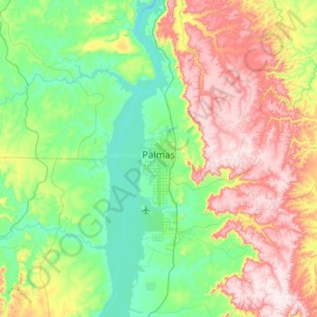
Palmas topographic map

Click on the map to display elevation.

Palmas

Palmas is located at the state's geographic centre at an average altitude of 230 m (755 ft). The city is located between the Serra do Lajeado hills on the east and the Tocantins River on the west. Palmas has a metropolitan area with 471,639 inhabitants.

Wikipedia (CC-BY-SA 3.0)

About this map

Name: Palmas topographic map, elevation, terrain.

Location: Palmas, Região Geográfica Imediata de Palmas, Região Geográfica Intermediária de Palmas, Tocantins, North Region, Brazil (-10.46000 -48.42293 -9.92344 -47.79327)

Average elevation: 367 m

Minimum elevation: 189 m

Maximum elevation: 711 m

Gear up for your next adventure:

🩹First Aid Kits - Emergency kits for hiking
🦘Outback Survival Gear - Essential gear for Australian outback
🧴Sunscreen SPF - Sun protection for outdoor activities
🪫Rechargeable Headlamps - USB rechargeable headlamps
🪢Paracord - Multi-purpose survival cord

As an Amazon Associate, this site earns from qualifying purchases at no extra cost to you.