Geolocate

Huacho topographic map

Click on the map to display elevation.

About this map

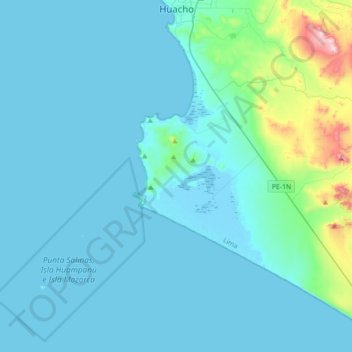
Name: Huacho topographic map, elevation, terrain.

Location: Huacho, Province of Huaura, Lima, Peru (-11.44718 -77.65423 -11.09990 -77.31990)

Average elevation: 69 m

Minimum elevation: -6 m

Maximum elevation: 727 m

Other topographic maps

Click on a map to view its topography, its elevation and its terrain.

Chiu Chiu

Peru > Lima > Barranca

Average elevation: 181 m

Gear up for your next adventure:

🧴SPF 50+ Bulk Sunscreen - Maximum protection for long-term outdoor exposure
Ultralight Solo Tents - Compact shelters for multi-day topographic surveying expeditions
🛠️Outdoor Repair Kits - Gear repair kits
📱Tablet Tripod Mounts - Steady platforms for viewing digital maps or taking long exposures
🧯Animal Deterrent Spray - Safety spray for wildlife

As an Amazon Associate, this site earns from qualifying purchases at no extra cost to you.