
Make a donation
Gear up for your next adventure:
As an Amazon Associate, this site earns from qualifying purchases at no extra cost to you.
Kainantu topographic map
Click on the map to display elevation.
Make a donation
Gear up for your next adventure:
As an Amazon Associate, this site earns from qualifying purchases at no extra cost to you.
Kainantu
A narrow south-east-trending dissected plateau dominates area to the south; it forms the watershed between rivers draining north to the Markham-Ramu Graben, and those draining south to the Papuan coast. The plateau ranges in elevation between 7,500 feet (2,300 m) and 8,000 feet (2,400 m) above sea level, and is about 2,500 feet (760 m) above the surrounding country. It is 11 miles (18 km) wide at its north-western end, but narrows to about 3 miles (4.8 km)to the south-east, where Nompia Creek cuts across it in a deep gorge . East of Nompia Creek, it is about 8 miles (13 km) wide, and the Lamari River flows across it in another deep gorge. The streams draining the plateau are mature over most of their courses, but near its edge they are deeply incised and flow along youthful valleys.
Make a donation
Gear up for your next adventure:
As an Amazon Associate, this site earns from qualifying purchases at no extra cost to you.
About this map
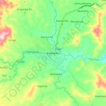
Name: Kainantu topographic map, elevation, terrain.
Average elevation: 1,628 m
Minimum elevation: 1,472 m
Maximum elevation: 1,915 m
Make a donation
Gear up for your next adventure:
As an Amazon Associate, this site earns from qualifying purchases at no extra cost to you.