Geolocate

Kayseri topographic map

Click on the map to display elevation.

Kayseri

Kayseri sits at the foot of Mount Erciyes (Turkish: Erciyes Dağı), a dormant volcano that reaches an altitude of 3,917 metres (12,851 feet), more than 1,500 metres above the city's mean altitude. It contains a number of historic monuments, particularly from the Seljuk period. Tourists often pass through Kayseri en route to the attractions of Cappadocia to the west.

Wikipedia (CC-BY-SA 3.0)

About this map

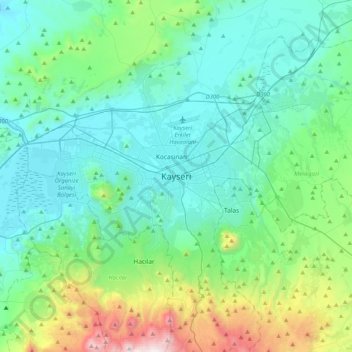
Name: Kayseri topographic map, elevation, terrain.

Location: Kayseri, Melikgazi, Kayseri, Central Anatolia Region, 38050, Turkey (38.56190 35.32732 38.88190 35.64732)

Average elevation: 1,345 m

Minimum elevation: 1,013 m

Maximum elevation: 2,795 m

Other topographic maps

Click on a map to view its topography, its elevation and its terrain.

Germir Mahallesi

Turkey > Melikgazi > Germir

Average elevation: 1,095 m

Albatros Parkı

Turkey > Melikgazi > Germir

Average elevation: 1,099 m

Gear up for your next adventure:

🎒Daypacks - Compact backpacks for short hikes
📱Tablet Tripod Mounts - Steady platforms for viewing digital maps or taking long exposures
🪑Portable Backpacking Chairs - A comfortable seat for studying maps at the end of the day
🛌Sleeping Bags - Sleeping bags for outdoor camping
📖Australian Bush Survival Books - Local knowledge on finding water and surviving the outback

As an Amazon Associate, this site earns from qualifying purchases at no extra cost to you.