Geolocate

Istanbul topographic map

Click on the map to display elevation.

About this map
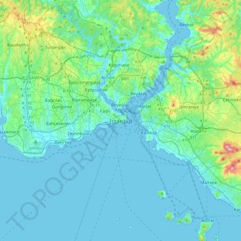
Name: Istanbul topographic map, elevation, terrain.

Location: Istanbul, Fatih, Istanbul, Marmara Region, 34122, Turkey (40.84638 28.81587 41.16638 29.13587)

Average elevation: 57 m

Minimum elevation: -2 m

Maximum elevation: 429 m

Other topographic maps

Click on a map to view its topography, its elevation and its terrain.
Balat Mahallesi

Turkey > Fatih

Average elevation: 33 m

Balat Mahallesi

Turkey > Fatih

Average elevation: 33 m

Gear up for your next adventure:

🔪Outdoor Multi-tools - Versatile tools for gear repair and survival tasks in the wilderness
🎒Tactical Waist Packs - Quick access to your compass, phone, and snacks while walking
🧭Military Style Lensatic Compass - Durable sighting compasses for advanced land navigation and surveying
👄SPF Lip Balm - Prevent sun and wind-burnt lips on mountain ridges
🌧️Rain Jackets - Waterproof jackets for hiking

As an Amazon Associate, this site earns from qualifying purchases at no extra cost to you.