
Make a donation
Gear up for your next adventure:
As an Amazon Associate, this site earns from qualifying purchases at no extra cost to you.
Marysville topographic map
Click on the map to display elevation.
Make a donation
Gear up for your next adventure:
As an Amazon Associate, this site earns from qualifying purchases at no extra cost to you.
Marysville
The city's topography varies from the low-lying downtown, located along the banks of Ebey Slough 5 feet (1.5 m) above sea level, rising to 160 feet (49 m) near Smokey Point and over 465 feet (142 m) in the eastern highlands. Marysville sits in the watershed of two major creeks, Quilceda Creek and Allen Creek, and approximately 70 minor streams that flow into Ebey Slough and Snohomish River. During the early 20th century, repeated controlled flooding and other engineering works in the Snohomish River delta contributed to the replenishment of the area's fertile silty soil for use in farming.
Make a donation
Gear up for your next adventure:
As an Amazon Associate, this site earns from qualifying purchases at no extra cost to you.
About this map
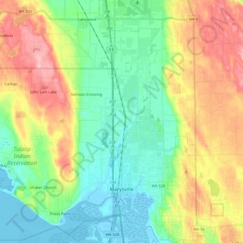
Name: Marysville topographic map, elevation, terrain.
Location: Marysville, Snohomish County, Washington, United States (48.01984 -122.28651 48.16329 -122.10961)
Average elevation: 72 m
Minimum elevation: -3 m
Maximum elevation: 201 m
Make a donation
Gear up for your next adventure:
As an Amazon Associate, this site earns from qualifying purchases at no extra cost to you.
Other topographic maps
Click on a map to view its topography, its elevation and its terrain.
Make a donation
Gear up for your next adventure:
As an Amazon Associate, this site earns from qualifying purchases at no extra cost to you.
Glacier Peak
United States > Washington > Snohomish County
Despite its elevation of 10,541 feet (3,213 m), Glacier Peak is a small stratovolcano. Its relatively high summit is a consequence of its location atop a high ridge, but its volcanic portion extends only 1,600–3,200 feet (500–1,000 m) above the underlying ridge. Another Cascade Arc volcano with similar…
Average elevation: 2,656 m
Make a donation
Gear up for your next adventure:
As an Amazon Associate, this site earns from qualifying purchases at no extra cost to you.
Bridal Veil Falls-Lower East Cascade
United States > Washington > Snohomish County
Average elevation: 621 m
Make a donation
Gear up for your next adventure:
As an Amazon Associate, this site earns from qualifying purchases at no extra cost to you.
Whitehorse Mountain
United States > Washington > Snohomish County
Whitehorse Mountain is a peak near the western edge of the North Cascades in Washington state. It is located just southwest of the Sauk River Valley town of Darrington, near the northern boundary of Boulder River Wilderness in Mount Baker-Snoqualmie National Forest. While not of particularly high absolute…
Average elevation: 1,430 m
Make a donation
Gear up for your next adventure:
As an Amazon Associate, this site earns from qualifying purchases at no extra cost to you.
Mill Creek
United States > Washington > Snohomish County > Mill Creek > Mill Creek
Average elevation: 129 m
Make a donation
Gear up for your next adventure:
As an Amazon Associate, this site earns from qualifying purchases at no extra cost to you.