
St. Neots topographic map
Click on the map to display elevation.
About this map
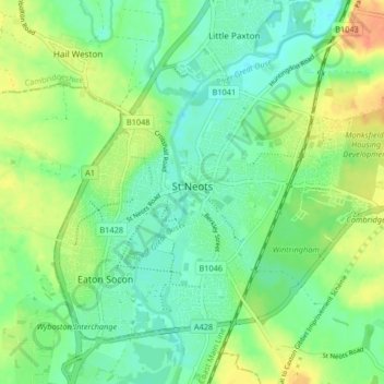
Name: St. Neots topographic map, elevation, terrain.
Average elevation: 25 m
Minimum elevation: 9 m
Maximum elevation: 50 m
Other topographic maps
Click on a map to view its topography, its elevation and its terrain.
Green End
United Kingdom > England > Cambridgeshire > Huntingdonshire > Great Stukeley
Average elevation: 32 m
Hinchingbrooke Country Park
United Kingdom > England > Cambridgeshire > Huntingdonshire > Huntingdon > Brampton
Average elevation: 16 m
Huntingdon Castle
United Kingdom > England > Cambridgeshire > Huntingdonshire > Huntingdon > Hartford
Average elevation: 14 m
Washingley
United Kingdom > England > Cambridgeshire > Huntingdonshire > Folksworth
Average elevation: 48 m
Holywell
United Kingdom > England > Cambridgeshire > Huntingdonshire > Holywell
Average elevation: 7 m
Hartford Marina
United Kingdom > England > Cambridgeshire > Huntingdonshire > Wyton
Average elevation: 14 m
Leighton Bromswold
United Kingdom > England > Cambridgeshire > Huntingdonshire
Average elevation: 49 m
Mill Pool
United Kingdom > England > Cambridgeshire > Huntingdonshire > Huntingdon
Average elevation: 14 m