
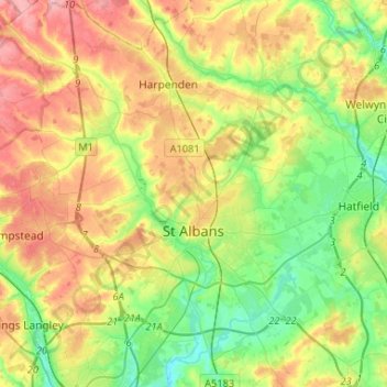
St Albans topographic map
Interactive map
Click on the map to display elevation.
About this map
Name: St Albans topographic map, elevation, terrain.
Average elevation: 107 m
Minimum elevation: 58 m
Maximum elevation: 175 m
St Albans was an ancient borough created following the dissolution of the monastery in 1539. It consisted of the ancient parish of St Albans (also known as the Abbey parish) and parts of St Michael and St Peter. The municipal corporation was reformed by the Municipal Corporations Act 1835 and the boundary was adjusted to additionally include part of the parish of St Stephen. In 1887 the borough gained city status, following the elevation of St Albans Abbey to cathedral, and the boundary was adjusted to include part of the parish of Sandridge.
Other topographic maps
Click on a map to view its topography, its elevation and its terrain.
Sandridge
United Kingdom > England > Hertfordshire > St Albans
Sandridge, St Albans, Hertfordshire, England, United Kingdom
Average elevation: 105 m
Frogmore
United Kingdom > England > Hertfordshire > St Albans
Frogmore, St Albans, Hertfordshire, England, AL2 2LS, United Kingdom
Average elevation: 80 m
Harpenden
United Kingdom > England > Hertfordshire > St Albans > Harpenden
Harpenden, St Albans, Hertfordshire, England, United Kingdom
Average elevation: 119 m