Geolocate

Chigwell topographic map

Click on the map to display elevation.

About this map

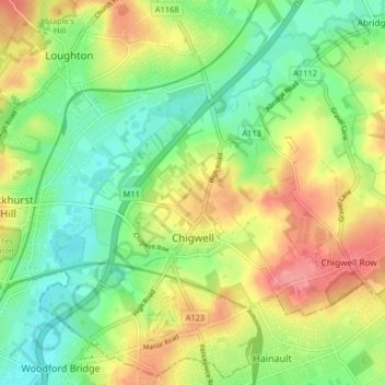
Name: Chigwell topographic map, elevation, terrain.

Location: Chigwell, Epping Forest, Essex, England, United Kingdom (51.60447 0.04803 51.65286 0.12916)

Average elevation: 43 m

Minimum elevation: 9 m

Maximum elevation: 88 m

Gear up for your next adventure:

📖Australian Bush Survival Books - Local knowledge on finding water and surviving the outback
📻Handheld UHF Radios - Critical communication for groups in the Australian outback
🧥Down Jackets - Insulated jackets for cold weather
Altimeter Barometer Watches - Outdoor watches with built-in sensors to track altitude changes and weather shifts
🛠️Outdoor Repair Kits - Gear repair kits

As an Amazon Associate, this site earns from qualifying purchases at no extra cost to you.