
Saint Barthélemy topographic map
Interactive map
Click on the map to display elevation.
Saint Barthélemy
Morne de Vitet, 286 metres (938 feet) in height, is the highest peak on the island. Hills and valleys of varying topography cover the rest of the island. Notable are Morne Rouge, Morne Criquet, Morne de Grand Fond, Morne de Dépoudré and Morne Lurin. The largest bodies of water on the island are Étang de Saint-Jean, Grande Saline, Grand Étang, and Petit Étang.
About this map
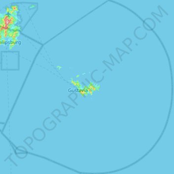
Name: Saint Barthélemy topographic map, elevation, terrain.
Location: Saint Barthélemy, 97133, France (17.67093 -63.06639 18.13756 -62.58440)
Average elevation: 2 m
Minimum elevation: -2 m
Maximum elevation: 407 m
Other topographic maps
Click on a map to view its topography, its elevation and its terrain.
Mont Blanc / Monte Bianco
France > Auvergne-Rhône-Alpes > Upper Savoy > Chamonix-Mont-Blanc
The climate is cold and temperate (Köppen climate classification Cfb), and is greatly influenced by altitude. Being the highest part of the Alps, Mont Blanc and surrounding mountains can create their own weather patterns. Temperatures drop as the mountains gain in height, and the summit of Mont Blanc is a…
Average elevation: 4,092 m
Les Résidences
France > Auvergne-Rhône-Alpes > Puy-de-Dôme > Murat-le-Quaire
Average elevation: 1,072 m
Siaugues-Saint-Romain
France > Auvergne-Rhône-Alpes > Haute-Loire > Siaugues-Sainte-Marie
Average elevation: 951 m
Les Baux
France > Pays de la Loire > Loire-Atlantique > Vair-sur-Loire > Saint-Herblon
Average elevation: 50 m
Tré-le-Champ - le Haut
France > Auvergne-Rhône-Alpes > Upper Savoy > Chamonix-Mont-Blanc
Average elevation: 1,737 m
Aix-en-Provence
France > Provence-Alpes-Côte d'Azur > Bouches-du-Rhône > Aix-en-Provence
Average elevation: 279 m
La Grave de Peille
France > Provence-Alpes-Côte d'Azur > Maritime Alps > Peille
Average elevation: 400 m
Paris
Paris in its early history had only the rivers Seine and Bièvre for water. From 1809, the Canal de l'Ourcq provided Paris with water from less-polluted rivers to the north-east of the capital. From 1857, the civil engineer Eugène Belgrand, under Napoleon III, oversaw the construction of a series of new…
Average elevation: 75 m
La Pierre de Neuvic
France > Nouvelle-Aquitaine > Haute-Vienne > Neuvic-Entier > La Pierre de Neuvic
Average elevation: 387 m
Le Revest-les-Eaux
France > Provence-Alpes-Côte d'Azur > Var > Le Revest-les-Eaux > Le Revest-les-Eaux
Average elevation: 327 m
La Pommeraye
France > Bourgogne – Franche-Comté > Saône-et-Loire > Beaurepaire-en-Bresse
Average elevation: 210 m
Pierrefitte-Nestalas
France > Occitania > Hautes Pyrenees > Pierrefitte-Nestalas > Pierrefitte-Nestalas
Average elevation: 712 m
Le Suquet
France > Provence-Alpes-Côte d'Azur > Maritime Alps > Lantosque > Le Suquet
Average elevation: 669 m
Le Grand Morétan
France > Auvergne-Rhône-Alpes > Saint-Colomban-des-Villards
Average elevation: 2,306 m
Prairie
France > Hauts-de-France > Cuignières
Certain extraordinary features were produced when the retreat of the ice sheet had progressed so far as to open an eastward outlet for the marginal lakes. This outlet occurred along the depression between the northward slope of the Appalachian plateau in west-central New York and the southward slope of the…
Average elevation: 136 m