Geolocate

Effingham topographic map

Click on the map to display elevation.

About this map

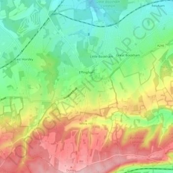
Name: Effingham topographic map, elevation, terrain.

Location: Effingham, Guildford, Surrey, England, United Kingdom (51.23516 -0.42506 51.29808 -0.38717)

Average elevation: 105 m

Minimum elevation: 26 m

Maximum elevation: 214 m

Gear up for your next adventure:

🔦LED Torches - LED torches for outdoor use
🕯️Emergency Whistles - Safety whistles for hiking
📚Map Reading & Navigation Guides - Master the art of interpreting topographic contours and symbols
🛌Sleeping Mats - Insulated mats for camping comfort
🌬️Windbreaker Jackets - Wind protection jackets

As an Amazon Associate, this site earns from qualifying purchases at no extra cost to you.