Geolocate

Nelson topographic map

Click on the map to display elevation.

About this map

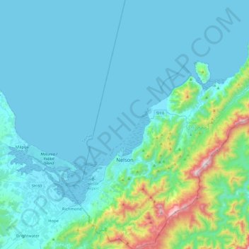
Name: Nelson topographic map, elevation, terrain.

Location: Nelson, New Zealand (-41.39343 173.18986 -41.05175 173.59876)

Average elevation: 143 m

Minimum elevation: -1 m

Maximum elevation: 1,199 m

Other topographic maps

Click on a map to view its topography, its elevation and its terrain.

Stoke

New Zealand > Nelson > Nelson

Average elevation: 114 m

Botanical Hill

New Zealand > Nelson > Nelson

Average elevation: 83 m

Grampians

New Zealand > Nelson > Nelson

Average elevation: 142 m

Grampians

New Zealand > Nelson > Nelson

Average elevation: 142 m

Todds Valley

New Zealand > Nelson > Nelson

Average elevation: 103 m

Hira

New Zealand > Nelson > Nelson

Average elevation: 159 m

Gentle Annie

New Zealand > Nelson > Nelson

Average elevation: 267 m

Wakapuaka River

New Zealand > Nelson > Nelson

Average elevation: 221 m

Grampians

New Zealand > Nelson > Nelson

Average elevation: 142 m

Gear up for your next adventure:

🎽Hiking Clothing - Breathable clothing for hiking
🎧Bluetooth Outdoor Earbuds - Listen to navigation cues or podcasts during long solo treks
🧭Military Style Lensatic Compass - Durable sighting compasses for advanced land navigation and surveying
🧺Waterproof Dry Sacks - Organize your pack and keep electronics safe from rain and river crossings
🔑Heavy Duty Carabiners - Secure gear to the outside of your pack for easy access

As an Amazon Associate, this site earns from qualifying purchases at no extra cost to you.