
Bezirk Landeck topographic map
Interactive map
Click on the map to display elevation.
About this map
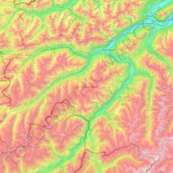
Name: Bezirk Landeck topographic map, elevation, terrain.
Location: Bezirk Landeck, Tyrol, Austria (46.82251 10.09783 47.25091 10.82162)
Average elevation: 2,061 m
Minimum elevation: 703 m
Maximum elevation: 3,681 m
Other topographic maps
Click on a map to view its topography, its elevation and its terrain.
Axamer Lizum
Austria > Tyrol > Bezirk Innsbruck-Land > Axams
The ski area is well known for a large variety of options to ski or snowboard off the marked piste. The highest location of the ski area is the mountain Hoadl with an altitude of 2,340 m, which is relatively high for a ski area in this region of the Alps. Thus, the Axamer Lizum has a reputation to be among the…
Average elevation: 1,858 m
Ströden
Austria > Tyrol > Bezirk Lienz > Gemeinde Prägraten am Großvenediger
Average elevation: 1,895 m
Brenner Pass
Austria > Tyrol > Bezirk Innsbruck-Land > Gemeinde Gries am Brenner > Brenner
Average elevation: 1,635 m