
Make a donation
Gear up for your next adventure:
As an Amazon Associate, this site earns from qualifying purchases at no extra cost to you.
Fullerton topographic map
Click on the map to display elevation.
Make a donation
Gear up for your next adventure:
As an Amazon Associate, this site earns from qualifying purchases at no extra cost to you.
Fullerton
Fullerton is located at 33°52′48″N 117°55′43″W / 33.88000°N 117.92861°W / 33.88000; -117.92861 (33.879914, -117.928749). It is approximately 25 miles (40 km) southeast of downtown Los Angeles, and approximately 11 miles (18 km) north-northwest of Santa Ana, the county seat. The city has a mean elevation of 150 feet (46 m) and lies approximately 11 miles (18 km) northeast of the Pacific Ocean straight-line distance. It has a Mediterranean climate, with a mean temperature of 62.2 °F (16.8 °C).
Make a donation
Gear up for your next adventure:
As an Amazon Associate, this site earns from qualifying purchases at no extra cost to you.
About this map
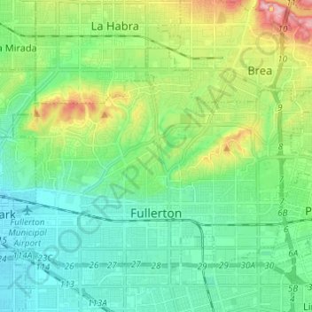
Name: Fullerton topographic map, elevation, terrain.
Average elevation: 79 m
Minimum elevation: 25 m
Maximum elevation: 225 m
Make a donation
Gear up for your next adventure:
As an Amazon Associate, this site earns from qualifying purchases at no extra cost to you.
Other topographic maps
Click on a map to view its topography, its elevation and its terrain.
Leisure World
United States > California > Orange County > Seal Beach > Leisure World
Average elevation: 6 m