Geolocate

Silang topographic map

Click on the map to display elevation.

About this map

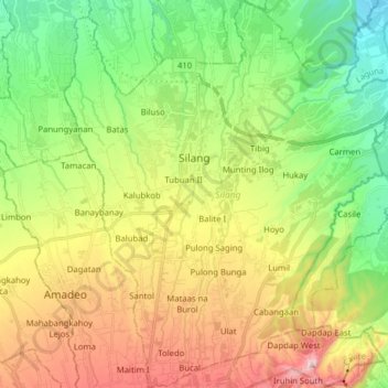
Name: Silang topographic map, elevation, terrain.

Location: Silang, Cavite, Calabarzon, 4118, Philippines (14.13291 120.92131 14.28543 121.05612)

Average elevation: 314 m

Minimum elevation: 46 m

Maximum elevation: 728 m

Other topographic maps

Click on a map to view its topography, its elevation and its terrain.

Asisan

Philippines > Cavite > Tagaytay

Average elevation: 526 m

Balubad

Philippines > Cavite > Silang

Average elevation: 377 m

Gear up for your next adventure:

Outdoor Coffee Makers - Enjoy quality coffee at the summit of your favorite peak
📱Tablet Tripod Mounts - Steady platforms for viewing digital maps or taking long exposures
📷Backpack Camera Clips - Quick access to your camera while keeping your hands free for climbing
🧣Merino Neck Gaiters - Versatile headwear for warmth, sun protection, or dust filtering
Altimeter Watches - Watches with altitude tracking

As an Amazon Associate, this site earns from qualifying purchases at no extra cost to you.